
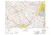
1956 Map of Newark
USGS Topo · Published 1956About this map
The industrial corridor of the Mid-Atlantic appears in high detail during the mid-1950s, anchored by the dense urban centers of Newark and Philadelphia. This regional study traces the heavy infrastructure that powered the post-war economy, from the newly established New Jersey Turnpike to the established rail networks of the Lehigh Valley RR and the Pennsylvania RR. The landscape transitions from the coastal wetlands of Raritan Bay and Barnegat Bay to the inland ridges of Blue Mountain and Broad Mountain, illustrating the topographical constraints that shaped early settlement patterns.
Find a feature on this map
167 named features on this map. Tap any name to fly to it.
Don’t see what you’re looking for? This feature index may not catch every label — zoom into the map to look around manually.
Map Details
Editions of this 1956 Newark Map
2 editions found
Other maps of this area

1884 · Whitings
USGS Topo · 1:62,500

1888 · Franklin
USGS Topo · 1:62,500

1888 · Plainfield
USGS Topo · 1:62,500

1888 · Bordentown
USGS Topo · 1:62,500

1888 · Pemberton
USGS Topo · 1:62,500

1888 · Barnegat
USGS Topo · 1:62,500

1888 · Morristown
USGS Topo · 1:62,500

1888 · Hackettstown
USGS Topo · 1:62,500

1888 · New Brunswick
USGS Topo · 1:62,500

1888 · Mount Holly
USGS Topo · 1:62,500