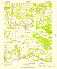
1956 Map of Newark
USGS Topo · Published 1957About this map
White River meanders in dramatic loops through this mid-century portrait of Independence County, defining the agricultural rhythm of Big Bottom and Vaughan. The landscape is a study in river-driven geography, where wide oxbows and islands like Pleasant Island and Padgett Island shaped the local economy. On the northern banks, the Missouri Pacific railroad corridor anchors the settlements of Newark and Magness, while to the south, the community of Oil Trough sits near the namesake Oil Trough Ferry. A high density of rural burial grounds, including Akron Cem, Dugger Cem, and Neutral Cem, provides a detailed record of early family settlements across the Wycough and Christian land divisions. The transition from the alluvial bottomlands to the rising terrain is marked by small upland landmarks such as Mount Carmel Ch and Mt Zion Ch.
Find a feature on this map
49 named features on this map. Tap any name to fly to it.
Don’t see what you’re looking for? This feature index may not catch every label — zoom into the map to look around manually.
Map Details
Editions of this 1956 Newark Map
This is the sole edition of this map. No revisions or reprints were ever made.
Other maps of this area

1890 · Batesville
USGS Topo · 1:125,000

1891 · Batesville
USGS Topo · 1:125,000

1932 · Strawberry
USGS Topo · 1:62,500

1935 · Strawberry
USGS Topo · 1:62,500

1935 · Newport
USGS Topo · 1:62,500

1941 · Strawberry
USGS Topo · 1:62,500

1942 · Salado
USGS Topo · 1:31,680

1943 · Sulphur Rock
USGS Topo · 1:31,680

1953 · Memphis
USGS Topo · 1:250,000

1954 · Charlotte
USGS Topo · 1:24,000