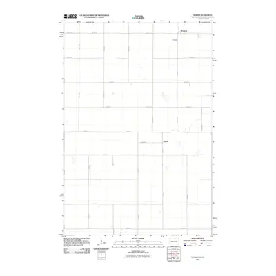
2011 Map of Newark
USGS Topo · Published 2011About this map
Brampton and Newark anchor this agricultural landscape along the border of North Dakota and South Dakota. The survey reveals a rigid, section-line road network that defines the region's farming heritage, with corridors such as Newark Rd and 125th Ave SE connecting the two small settlements. This rural layout is punctuated by numerous small depressions and seasonal wetlands typical of the prairie pothole region, appearing between the grid of roads. Genealogists will find the Brampton Cemetery north of the township road, serving as a primary local landmark for the surrounding Brampton Township. The map illustrates how late-twentieth-century land management preserved the township's primary transport arteries, such as 100th St SE, while maintaining the open, agrarian character of the High Plains.
Find a feature on this map
26 named features on this map. Tap any name to fly to it.
Don’t see what you’re looking for? This feature index may not catch every label — zoom into the map to look around manually.
Map Details
Editions of this 2011 Newark Map
This is the sole edition of this map. No revisions or reprints were ever made.
Other maps of this area

1953 · Britton East
USGS Topo · 1:24,000

1953 · Newark SW
USGS Topo · 1:24,000

1953 · Kidder
USGS Topo · 1:24,000

1953 · Newark
USGS Topo · 1:24,000

1953 · Milbank
USGS Topo · 1:250,000

1953 · Fargo
USGS Topo · 1:250,000

1956 · Fargo
USGS Topo · 1:250,000
1956 · Straubville
USGS Topo · 1:24,000

1956 · Britton West
USGS Topo · 1:24,000

1956 · Newark NW
USGS Topo · 1:24,000