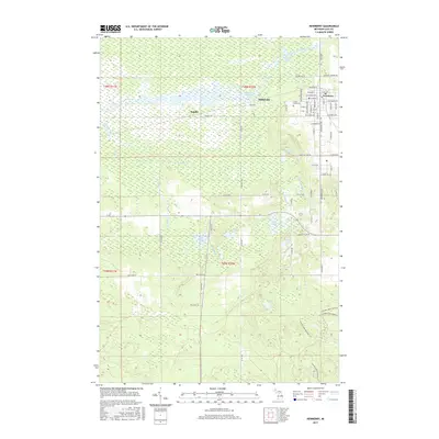
2017 Map of Newberry
USGS Topo · Published 2017About this map
Newberry serves as the regional hub in this modern survey of Luce County, anchoring a landscape where the Tahquamenon River and the expansive Dollarville Flooding dominate the northern terrain. The village grid of Newberry is shown in detail, including street names from W Truman Blvd to E McMillan Ave, and the location of Forest Home Cem. Moving west, the smaller settlements of Dollarville and Natalie appear alongside the winding river and its many tributaries, such as Teaspoon Creek and Petes Cr. The southern half of the map transitions into a dense wetland and lake district, featuring named water bodies like Kuks Lake, Maki Lake, and Merwin Lake. Recreation and conservation are evident through the Canada Lakes Pathway, which winds through the southeastern portion of the quadrangle, illustrating the contemporary character of this Upper Peninsula wilderness.
Find a feature on this map
49 named features on this map. Tap any name to fly to it.
Don’t see what you’re looking for? This feature index may not catch every label — zoom into the map to look around manually.
Map Details
Editions of this 2017 Newberry Map
This is the sole edition of this map. No revisions or reprints were ever made.
Other maps of this area

1931 · Gould City NE
USGS Topo · 1:31,680

1931 · Gould City NW
USGS Topo · 1:31,680

1931 · Gilchrist NW
USGS Topo · 1:31,680

1954 · Sault Sainte Marie
USGS Topo · 1:250,000

1956 · Sault Sainte Marie
USGS Topo · 1:250,000

1957 · Sault Sainte Marie
USGS Topo · 1:250,000

1958 · Sault Sainte Marie
USGS Topo · 1:250,000

1962 · Auger Lake
USGS Topo · 1:24,000
1973 · Curtis East
USGS Topo · 1:24,000
1973 · McMillan
USGS Topo · 1:24,000