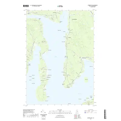
2021 Map of Newbury Neck
USGS Topo · Published 2021About this map
Newbury Neck Road bisects the long peninsula separating Morgan Bay from the Union River Bay, illustrating a coastal Maine landscape where historical settlement patterns are closely tied to the water. In the early 21st century, the area around Surry and Ellsworth remains defined by its maritime geography and numerous family-named landmarks. The map is a significant resource for genealogists, documenting over a dozen small burial grounds including the Haynes - Gilley - Jordan Cemetery and the Whittenmore Cemetery. Shoreline features like Carrying Place and Poignant Point suggest the long-standing use of these waters for local navigation and transit. To the east, the village of West Trenton and the surrounding Goose Cove area show a network of local roads such as Bayside Road and Oak Point Road that connect isolated coastal homesteads.
Find a feature on this map
122 named features on this map. Tap any name to fly to it.
Don’t see what you’re looking for? This feature index may not catch every label — zoom into the map to look around manually.
Map Details
Editions of this 2021 Newbury Neck Map
This is the sole edition of this map. No revisions or reprints were ever made.
Other maps of this area

1900 · Orland
USGS Topo · 1:62,500

1904 · Mount Desert
USGS Topo · 1:62,500

1904 · Bluehill
USGS Topo · 1:62,500

1905 · Penobscot Bay
USGS Topo · 1:125,000

1911 · Ellsworth
USGS Topo · 1:62,500

1940 · Ellsworth
USGS Topo · 1:62,500

1942 · Orland
USGS Topo · 1:62,500

1942 · Ellsworth
USGS Topo · 1:62,500

1942 · Mount Desert
USGS Topo · 1:62,500

1944 · Blue Hill
USGS Topo · 1:62,500