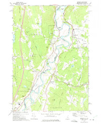
1973 Map of Newbury
USGS Topo · Published 1975About this map
The Connecticut River forms the sinuous spine of this early 1970s survey, marking the border between Newbury, Vermont, and Haverhill, New Hampshire. The landscape is defined by its wide floodplains and dramatic river loops, most notably at The Oxbow and Horse Meadow. Transportation patterns are dictated by the waterway, with the Boston and Maine Railroad and River Road paralleling the banks to serve riverfront settlements.
Find a feature on this map
54 named features on this map. Tap any name to fly to it.
Don’t see what you’re looking for? This feature index may not catch every label — zoom into the map to look around manually.
Map Details
Editions of this 1973 Newbury Map
This is the sole edition of this map. No revisions or reprints were ever made.
Other maps of this area

1928 · Rumney
USGS Topo · 1:62,500

1929 · Moosilauke
USGS Topo · 1:62,500

1931 · Mt. Cube
USGS Topo · 1:62,500

1931 · Woodsville
USGS Topo · 1:48,000

1932 · Rumney
USGS Topo · 1:62,500

1932 · Moosilauke
USGS Topo · 1:62,500

1933 · Mt. Cube
USGS Topo · 1:62,500

1935 · Woodsville
USGS Topo · 1:62,500

1941 · Woodsville
USGS Topo · 1:62,500

1949 · Portland
USGS Topo · 1:250,000