
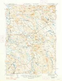
1944 Map of Newfield
USGS Topo · Published 1944About this map
The Little Ossipee River and its numerous tributaries dominate this mid-century landscape on the New Hampshire border, illustrating a region defined by its water-powered industrial past and recreational lakefronts. Small mill-centric settlements like Limerick Mills, Ossipee Mills, and Milton Mills highlight the historical importance of local watercourses for early manufacturing. The map documents the extensive water network of the York Co and Carroll Co borderlands, featuring prominent bodies such as Great East Lake, Square Pond, and Mousam Lake. Inland, the terrain is marked by numerous family-named peaks and ridges, including Randall Mtn, Sawyer Mtn, and Dearborn Mtn, which frame the scattered villages. The infrastructure of the era is captured through labels for established crossroads and hamlets like South Parsonsfield, North Shapleigh, and Sprague City, providing a detailed look at the rural settlement patterns before modern development significantly altered the landscape.
Find a feature on this map
120 named features on this map. Tap any name to fly to it.
Don’t see what you’re looking for? This feature index may not catch every label — zoom into the map to look around manually.
Map Details
Editions of this 1944 Newfield Map
2 editions found
Other maps of this area

1891 · Berwick
USGS Topo · 1:62,500

1891 · Kennebunk
USGS Topo · 1:62,500

1891 · Buxton
USGS Topo · 1:62,500

1891 · Newfield
USGS Topo · 1:62,500

1892 · Buxton
USGS Topo · 1:62,500

1893 · Kennebunk
USGS Topo · 1:62,500

1893 · Berwick
USGS Topo · 1:62,500

1893 · Buxton
USGS Topo · 1:62,500

1893 · Newfield
USGS Topo · 1:62,500

1896 · Sebago
USGS Topo · 1:62,500