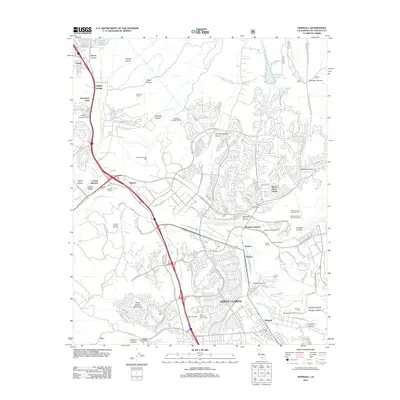
2012 Map of Newhall
USGS Topo · Published 2012About this map
The Santa Clara River valley and its surrounding canyons define this landscape of suburban expansion and industrial utility in Los Angeles County. Large-scale infrastructure is prominent, notably the Los Angeles Aqueduct and the Dry Canyon Reservoir in the north, while the southern reaches show the dense residential patterns of Santa Clarita and Newhall. The region's petroleum history remains visible through active installations like the Honor Rancho Oil Field and the Castaic Junction Oil Field, which share the valley floor with the Saugus Speedway. Institutional land use is also significant here, with specialized facilities such as Forestry Camp Number Four and Junior Probation Camp Number Four situated in the hills east of the S Fork Santa Clara River.
Find a feature on this map
127 named features on this map. Tap any name to fly to it.
Don’t see what you’re looking for? This feature index may not catch every label — zoom into the map to look around manually.
Map Details
Editions of this 2012 Newhall Map
This is the sole edition of this map. No revisions or reprints were ever made.
Other maps of this area

1900 · Fernando
USGS Topo · 1:62,500

1901 · Southern California Sheet No. 1
USGS Topo · 1:250,000

1903 · Tejon
USGS Topo · 1:125,000

1903 · Camulos
USGS Topo · 1:125,000

1903 · Santa Susana
USGS Topo · 1:62,500

1904 · Southern California Sheet No. 1
USGS Topo · 1:250,000

1915 · Elizabeth Lake
USGS Topo · 1:125,000

1917 · Elizabeth Lake
USGS Topo · 1:125,000

1925 · Sylmar
USGS Topo · 1:24,000

1928 · Sylmar
USGS Topo · 1:24,000
Featured Places
- Santa Clarita, CA
- Ninetynine Oaks, CA
- Sulphur Springs, CA
- Pardee, Santa Clarita
- Bouquet Junction, Santa Clarita