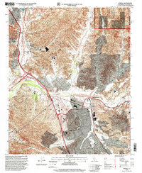
1995 Map of Newhall
USGS Topo · Published 1999About this map
The Santa Clara River valley in northern Los Angeles County shows a landscape of rapid suburbanization alongside deep-rooted industrial and agricultural history. By the mid-1990s, the master-planned communities of Valencia and Santa Clarita appear fully integrated with older settlements like Saugus and Newhall. This transition is evident in the proximity of modern institutions like the California Institute of the Arts and Henry Mayo Newhall Memorial Hospital to the rugged foothills of the Santa Susana Mountains.
Find a feature on this map
45 named features on this map. Tap any name to fly to it.
Don’t see what you’re looking for? This feature index may not catch every label — zoom into the map to look around manually.
Map Details
Editions of this 1995 Newhall Map
This is the sole edition of this map. No revisions or reprints were ever made.
Other maps of this area

1900 · Fernando
USGS Topo · 1:62,500

1901 · Southern California Sheet No. 1
USGS Topo · 1:250,000

1903 · Tejon
USGS Topo · 1:125,000

1903 · Camulos
USGS Topo · 1:125,000

1903 · Santa Susana
USGS Topo · 1:62,500

1904 · Southern California Sheet No. 1
USGS Topo · 1:250,000

1915 · Elizabeth Lake
USGS Topo · 1:125,000

1917 · Elizabeth Lake
USGS Topo · 1:125,000

1925 · Sylmar
USGS Topo · 1:24,000

1928 · Sylmar
USGS Topo · 1:24,000
Featured Places
- Santa Clarita, CA
- Sulphur Springs, CA
- Pardee, Santa Clarita
- Rancho Santa Clarita, Santa Clarita
- Castaic, CA