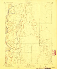
1912 Map of Newhard
USGS Topo · Published 1912About this map
The Sacramento River dominates this 1912 survey, winding through a complex landscape of oxbow lakes and historical land grants on the border of Butte and Glenn counties. The river's importance to early 20th-century commerce is evident in the multiple riverbank outposts, including Parrott Landing, Hites Landing, and Newhard Landing. These points served as vital connections for the surrounding agricultural tracts, notably the large ranchos such as Llano Seco and Rancho de Farwell.
Find a feature on this map
19 named features on this map. Tap any name to fly to it.
Don’t see what you’re looking for? This feature index may not catch every label — zoom into the map to look around manually.
Map Details
Editions of this 1912 Newhard Map
This is the sole edition of this map. No revisions or reprints were ever made.
Other maps of this area

1888 · Marysville
USGS Topo · 1:125,000

1891 · Chico
USGS Topo · 1:125,000

1891 · Marysville
USGS Topo · 1:125,000

1893 · Chico
USGS Topo · 1:125,000

1894 · Marysville
USGS Topo · 1:125,000

1895 · Marysville
USGS Topo · 1:125,000

1895 · Chico
USGS Topo · 1:125,000

1906 · Maxwell
USGS Topo · 1:62,500

1906 · Willows
USGS Topo · 1:62,500

1911 · Landlow
USGS Topo · 1:31,680