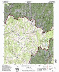
1994 Map of Newland
USGS Topo · Published 1998About this map
Newland serves as the central hub of this Avery County survey, where the Blue Ridge Parkway winds through the high terrain of the Pisgah National Forest. The landscape is defined by the Blue Ridge and Valley Divide, with settlements like Minneapolis, Montezuma, and Crossnore established along the valleys and gaps. Genealogists will find a wealth of local landmarks, from the Forest Home Church Summerow Cemetery to the Fletcher Chapel and Big Meadow Church. The map details a mountain economy supported by resources and recreation, featuring an Open Pit Mine near Little Elk Mountain, a Trout Rearing Station on the Linville River, and several camps such as Camp Linn-Haven. From the Pinnacle of the Sugar to the North Toe River, this record captures the rural character of the High Country before late-century growth.
Find a feature on this map
120 named features on this map. Tap any name to fly to it.
Don’t see what you’re looking for? This feature index may not catch every label — zoom into the map to look around manually.
Map Details
Editions of this 1994 Newland Map
This is the sole edition of this map. No revisions or reprints were ever made.
Other maps of this area

1891 · Roan Mountain
USGS Topo · 1:125,000

1893 · Cranberry
USGS Topo · 1:125,000

1894 · Roan Mountain
USGS Topo · 1:125,000

1895 · Cranberry
USGS Topo · 1:125,000

1899 · Cranberry
USGS Topo · 1:125,000

1900 · Mount Mitchell
USGS Topo · 1:125,000

1902 · Cranberry
USGS Topo · 1:125,000

1902 · Mount Mitchell
USGS Topo · 1:125,000

1904 · Roan Mountain
USGS Topo · 1:125,000

1905 · Morganton
USGS Topo · 1:125,000