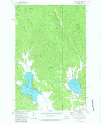
1973 Map of Newman Lake
USGS Topo · Published 1983About this map
Newman Lake and Hauser Lake anchor this 1970s landscape along the border of Washington and Idaho. The map captures a moment of transition between the wild slopes of Mount Spokane State Park and the burgeoning recreational developments along the water's edge. Detailed shorelines reveal a mix of public and private access points, including the Homestead Campground and the residential layout at Hauser.
Find a feature on this map
40 named features on this map. Tap any name to fly to it.
Don’t see what you’re looking for? This feature index may not catch every label — zoom into the map to look around manually.
Map Details
Editions of this 1973 Newman Lake Map
3 editions found
Other maps of this area

1901 · Spokane
USGS Topo · 1:125,000

1903 · Rathdrum
USGS Topo · 1:125,000

1943 · Mt Spokane
USGS Topo · 1:62,500

1949 · Greenacres
USGS Topo · 1:62,500

1950 · Mt Spokane
USGS Topo · 1:62,500

1951 · Greenacres
USGS Topo · 1:62,500

1955 · Spokane
USGS Topo · 1:250,000

1957 · Coeur D'Alene
USGS Topo · 1:62,500

1958 · Spokane
USGS Topo · 1:250,000

1961 · Rathdrum
USGS Topo · 1:24,000