1932 Map of Newport Beach
USGS Topo · Published 1932About this map
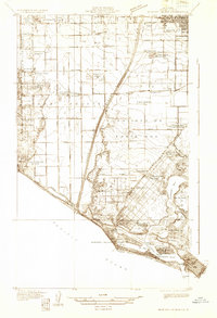
Newport Bay and the winding Santa Ana River define this coastal landscape during a period of significant agricultural and maritime development. Inland, the map reveals a grid of truck farms and small settlements like Colonia Juarez and Greenville, supported by rail sidings such as Sugar Siding and Thurin Siding. The coastal zone is already established as a recreation and navigation hub, featuring the Newport Harbor Yacht Club and the Balboa Ferry connecting the peninsula to Balboa Beach.
Find a feature on this map
50 named features on this map. Tap any name to fly to it.
Don’t see what you’re looking for? This feature index may not catch every label — zoom into the map to look around manually.
Map Details
Editions of this 1932 Newport Beach Map
This is the sole edition of this map. No revisions or reprints were ever made.
Other maps of this area

1896 · Santa Ana
USGS Topo · 1:62,500

1896 · Anaheim
USGS Topo · 1:62,500

1896 · Las Bolsas
USGS Topo · 1:62,500

1896 · Downey
USGS Topo · 1:62,500

1898 · Anaheim
USGS Topo · 1:62,500

1899 · Downey
USGS Topo · 1:62,500

1901 · Southern California Sheet No. 1
USGS Topo · 1:250,000

1901 · Santa Ana
USGS Topo · 1:62,500

1901 · Anaheim
USGS Topo · 1:62,500

1902 · Downey
USGS Topo · 1:62,500