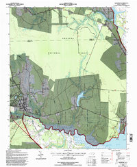
1994 Map of Newport
USGS Topo · Published 1997About this map
Croatan National Forest dominates the interior of this coastal North Carolina landscape, where the Newport River meanders toward the coast. The town of Newport serves as a local hub, situated near the East Carolina Railroad corridor and containing the Newport Cem. This 1990s revision reveals a mixture of established community life and federal land management, with small settlements like North Harlowe and Union Point dotting the periphery of the forest. To the north, religious centers such as Hymans Chapel and Pilgrims Rest BM Ch indicate the historical social fabric of the rural area. The presence of a Prison Camp near the river and the Neusiok Trail cutting through the forest highlights the diverse land uses in this section of Craven and Carteret counties.
Find a feature on this map
42 named features on this map. Tap any name to fly to it.
Don’t see what you’re looking for? This feature index may not catch every label — zoom into the map to look around manually.
Map Details
Editions of this 1994 Newport Map
This is the sole edition of this map. No revisions or reprints were ever made.
Other maps of this area

1949 · Havelock
USGS Topo · 1:24,000

1949 · Beaufort
USGS Topo · 1:24,000

1949 · Merrimon
USGS Topo · 1:24,000

1949 · Newport
USGS Topo · 1:24,000

1949 · Salter Path
USGS Topo · 1:24,000

1949 · Mansfield
USGS Topo · 1:24,000

1949 · Cherry Point
USGS Topo · 1:24,000

1949 · Core Creek
USGS Topo · 1:24,000

1949 · Masontown
USGS Topo · 1:24,000

1951 · Salter Path
USGS Topo · 1:24,000