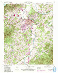
1961 Map of Newport
USGS Topo · Published 1993About this map
The Pigeon River flows north to meet the French Broad River at the heart of this East Tennessee landscape, anchoring the development of Newport. The town serves as a critical junction for the Southern Railway and the Dixie Highway, reflecting a mid-century period of transition where industrial sites like Tannery Island and a strip mine sit alongside traditional neighborhood names such as Northport, Eastport, and Jintown. Rural life remains deeply rooted in the surrounding terrain, evidenced by numerous family-named landmarks and gathering places.
Find a feature on this map
101 named features on this map. Tap any name to fly to it.
Don’t see what you’re looking for? This feature index may not catch every label — zoom into the map to look around manually.
Map Details
Editions of this 1961 Newport Map
3 editions found
Other maps of this area

1883 · Morristown
USGS Topo · 1:125,000

1893 · Mt Guyot
USGS Topo · 1:125,000

1893 · Morristown
USGS Topo · 1:125,000

1895 · Morristown
USGS Topo · 1:125,000

1912 · Mt Guyot
USGS Topo · 1:125,000

1935 · Newport
USGS Topo · 1:48,000

1935 · White Pine
USGS Topo · 1:24,000

1935 · Hartford
USGS Topo · 1:24,000

1935 · English Mountain
USGS Topo · 1:48,000

1935 · Parrottsville
USGS Topo · 1:24,000