
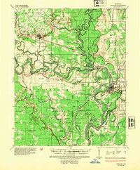
1935 Map of Newport
USGS Topo · Published 1937About this map
White River meanders sharply through Jackson and Independence counties, defining a landscape of active levees and flood-prone lowlands. The 1930s terrain is marked by the Bateman Levee and Mayberry Levee, protecting rail hubs like Newark and Newport from the unpredictable river channel. To the west, the Ozark Escarpment provides a distinct rise above the river bottomlands, where family names are etched into the landscape at Sisk Pl and Palmer Pl.
Find a feature on this map
123 named features on this map. Tap any name to fly to it.
Don’t see what you’re looking for? This feature index may not catch every label — zoom into the map to look around manually.
Map Details
Editions of this 1935 Newport Map
2 editions found
Other maps of this area

1890 · Batesville
USGS Topo · 1:125,000

1891 · Batesville
USGS Topo · 1:125,000

1932 · Strawberry
USGS Topo · 1:62,500

1935 · Alicia
USGS Topo · 1:62,500

1935 · Strawberry
USGS Topo · 1:62,500

1935 · Augusta
USGS Topo · 1:62,500

1935 · Tuckerman
USGS Topo · 1:62,500

1935 · Bald Knob
USGS Topo · 1:62,500

1940 · Tilton
USGS Topo · 1:62,500

1941 · Strawberry
USGS Topo · 1:62,500