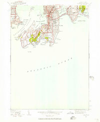
1939 Map of Newport
USGS Topo · Published 1957About this map
Fort Adams stands as a prominent sentinel overlooking Newport Harbor, anchoring a landscape defined by coastal defense and Gilded Age estates just before the start of World War II. This survey reveals the dense urban grid of Newport and the developing residential reaches of Middletown, contrasted by the strategic military presence at Fort Wetherill on Conanicut Island. The map meticulously records the era's social and educational infrastructure, from the exclusive grounds of the Newport Country Club and St Georges Sch to the public greens at Touro Park. Along the Atlantic shoreline, the rocky geography that defined the city's character is labeled in detail, including Forty Steps, Purgatory, and Lands End. The distribution of cemeteries like Island Cem and early schools provides essential context for researchers looking at the mid-century evolution of this maritime hub.
Find a feature on this map
66 named features on this map. Tap any name to fly to it.
Don’t see what you’re looking for? This feature index may not catch every label — zoom into the map to look around manually.
Map Details
Editions of this 1939 Newport Map
This is the sole edition of this map. No revisions or reprints were ever made.
Other maps of this area

1885 · Sakonnet
USGS Topo · 1:62,500

1888 · Fall River
USGS Topo · 1:62,500

1888 · Sakonnet
USGS Topo · 1:62,500

1889 · Newport
USGS Topo · 1:62,500

1890 · Narragansett Bay
USGS Topo · 1:62,500

1892 · Narragansett Bay
USGS Topo · 1:62,500

1893 · Sakonnet
USGS Topo · 1:62,500

1893 · Fall River
USGS Topo · 1:62,500

1894 · Newport
USGS Topo · 1:62,500

1904 · Newport
USGS Topo · 1:62,500