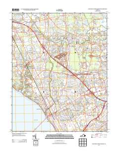
2013 Map of Newport News North
USGS Topo · Published 2013About this map
Big Bethel Battlefield stands as a central historical landmark in this region of the Virginia Peninsula, marking a landscape defined by significant military and scientific installations. The eastern portion of the map is dominated by the sprawling Langley Air Force Base and the adjacent Langley Research And Development Park, which sit near the tidal waters of Tabbs Cr. In the west, the Thomas Jefferson National Accelerator Facility highlights the area's modern role as a center for high-tech research and physics.
Find a feature on this map
75 named features on this map. Tap any name to fly to it.
Don’t see what you’re looking for? This feature index may not catch every label — zoom into the map to look around manually.
Map Details
Editions of this 2013 Newport News North Map
This is the sole edition of this map. No revisions or reprints were ever made.
Other maps of this area

1907 · Norfolk
USGS Topo · 1:125,000

1907 · Yorktown
USGS Topo · 1:62,500

1907 · Hampton
USGS Topo · 1:62,500

1919 · Smithfield
USGS Topo · 1:62,500

1921 · Newport News
USGS Topo · 1:62,500

1943 · Yorktown
USGS Topo · 1:62,500

1943 · Richmond
USGS Topo · 1:250,000

1944 · Hampton
USGS Topo · 1:24,000

1944 · Yorktown
USGS Topo · 1:24,000

1944 · Messick
USGS Topo · 1:24,000