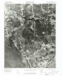
1973 Map of Newport News North
USGS Topo · Published 1977About this map
Industrial and residential development lines the northern shore of the James River in this 1973 orthophotoquad, capturing a period of significant suburban expansion in Tidewater Virginia. Unlike traditional topographic maps, this aerial imagery provides a direct photographic record of the landscape as documented by the Division of Mineral Resources under State Geologist James L. Calver. The dense grid of contemporary neighborhoods in Newport News and the western portion of Hampton contrasts sharply with the wooded tracts and winding creek beds that remain undeveloped to the north. This document records the exact footprint of the mid-1970s coastal city, showing the precise alignment of major thoroughfares and the evolving shoreline before later decades of waterfront transformation and infill development.
Find a feature on this map
3 named features on this map. Tap any name to fly to it.
Don’t see what you’re looking for? This feature index may not catch every label — zoom into the map to look around manually.
Map Details
Editions of this 1973 Newport News North Map
This is the sole edition of this map. No revisions or reprints were ever made.
Other maps of this area

1907 · Norfolk
USGS Topo · 1:125,000

1907 · Yorktown
USGS Topo · 1:62,500

1907 · Hampton
USGS Topo · 1:62,500

1919 · Smithfield
USGS Topo · 1:62,500

1921 · Newport News
USGS Topo · 1:62,500

1943 · Yorktown
USGS Topo · 1:62,500

1943 · Richmond
USGS Topo · 1:250,000

1944 · Hampton
USGS Topo · 1:24,000

1944 · Yorktown
USGS Topo · 1:24,000

1944 · Messick
USGS Topo · 1:24,000