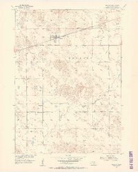
1954 Map of Newport
USGS Topo · Published 1956About this map
Newport sits as a primary rail hub along the Chicago and North Western line, serving as a critical transport point for the surrounding cattle country in the mid-1950s. The landscape is defined by the hydrologic network of the North Fork Elkhorn River and the South Fork Elkhorn River, which meander through a terrain dotted with numerous depressions and windmills. Rural life is anchored by several local landmarks, including School No 21 and School No 26, reflecting the distributed nature of the community at this time. South of the main settlement, the locality of Lay and features such as Dry Creek and a Flowing Well indicate a reliance on specific water sources for both livestock and agriculture. This survey provides a clear view of the regional infrastructure before significant modern modernization, preserving the locations of early 20th-century schoolhouses and rail sidings.
Find a feature on this map
15 named features on this map. Tap any name to fly to it.
Don’t see what you’re looking for? This feature index may not catch every label — zoom into the map to look around manually.
Map Details
Editions of this 1954 Newport Map
2 editions found
Other maps of this area

1949 · Carns
USGS Topo · 1:24,000

1950 · Carns
USGS Topo · 1:24,000

1954 · Stuart
USGS Topo · 1:24,000

1954 · Stuart NW
USGS Topo · 1:24,000

1954 · Newport NE
USGS Topo · 1:24,000

1954 · Newport
USGS Topo · 1:24,000

1954 · Newport SW
USGS Topo · 1:24,000

1955 · O'Neill
USGS Topo · 1:250,000

1959 · O'Neill
USGS Topo · 1:250,000

1969 · O'Neill
USGS Topo · 1:250,000