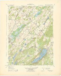
1943 Map of Newton East
USGS Topo · Published 1943About this map
Dairy operations and heavy industry define the landscape of central Sussex County in the early 1940s. The agricultural character of the region is evident through named facilities like Ideal Farms, North Jersey Dairy Land, and the H Becker & Son Inc Milk Sta, while the region's extraction history is visible at the Slate Quarry near the northern border and the F W Bennett Sand and Gravel Quarry further south.
Find a feature on this map
58 named features on this map. Tap any name to fly to it.
Don’t see what you’re looking for? This feature index may not catch every label — zoom into the map to look around manually.
Map Details
Editions of this 1943 Newton East Map
This is the sole edition of this map. No revisions or reprints were ever made.
Other maps of this area

1888 · Franklin
USGS Topo · 1:62,500

1888 · Hackettstown
USGS Topo · 1:62,500

1888 · Lake Hopatcong
USGS Topo · 1:62,500

1891 · Wallpack
USGS Topo · 1:62,500

1893 · Wallpack
USGS Topo · 1:62,500

1894 · Hackettstown
USGS Topo · 1:62,500

1894 · Lake Hopatcong
USGS Topo · 1:62,500

1894 · Franklin
USGS Topo · 1:62,500

1897 · Franklin
USGS Topo · 1:62,500

1898 · Lake Hopatcong
USGS Topo · 1:62,500