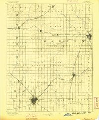
1889 Map of Newton
USGS Topo · Published 1889About this map
The growing rail hub of Newton anchors this late-nineteenth-century survey of the Central Kansas plains, capturing a landscape undergoing rapid agricultural and industrial organization. Three major rail lines dominate the geography, reflecting the era's competitive expansion: the Atchison Topeka and Santa Fe Railroad cuts diagonally through the territory, while the Chicago Kansas and Nebraska Railroad and Missouri Pacific Railroad establish critical connections to outlying towns like Peabody and Marion.
Find a feature on this map
59 named features on this map. Tap any name to fly to it.
Don’t see what you’re looking for? This feature index may not catch every label — zoom into the map to look around manually.
Map Details
Editions of this 1889 Newton Map
This is the sole edition of this map. No revisions or reprints were ever made.
Other maps of this area
1888 · Eldorado
USGS Topo · 1:125,000
1889 · Abilene
USGS Topo · 1:125,000
1889 · Parkerville
USGS Topo · 1:125,000
1889 · Cheney
USGS Topo · 1:125,000

1889 · Wichita
USGS Topo · 1:125,000
1891 · Hutchinson
USGS Topo · 1:125,000
1891 · Cheney
USGS Topo · 1:125,000
1892 · Salina
USGS Topo · 1:125,000
1893 · Hutchinson
USGS Topo · 1:125,000
1894 · Wichita
USGS Topo · 1:125,000