1944 Map of Newton
USGS Topo · Published 1944About this map
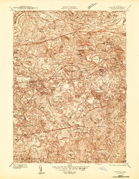
The Charles River winds through a landscape of established suburban villages and institutional landmarks just before the end of World War II. This 1944 preliminary edition highlights the dense settlement patterns of Newton Center, Waltham, and West Roxbury, connected by the extensive tracks of the Boston and Albany RR and the New York New Haven and Hartford RR. The map reveals a high concentration of educational and medical institutions, including Boston College, Harvard University, and the Perkins Institution for Blind, alongside the Arsenal US Military Reservation in Watertown. Researchers will find significant genealogical data in the numerous burial grounds like Holyhood Cem and Newton Cem, while the intricate contour lines define prominent elevations such as Waban Hill and Oak Hill that shaped the region's development.
Find a feature on this map
120 named features on this map. Tap any name to fly to it.
Don’t see what you’re looking for? This feature index may not catch every label — zoom into the map to look around manually.
Map Details
Editions of this 1944 Newton Map
This is the sole edition of this map. No revisions or reprints were ever made.
Other maps of this area

1886 · Dedham
USGS Topo · 1:62,500

1886 · Framingham
USGS Topo · 1:62,500

1887 · Franklin
USGS Topo · 1:62,500

1889 · Franklin
USGS Topo · 1:62,500

1889 · Framingham
USGS Topo · 1:62,500

1893 · Franklin
USGS Topo · 1:62,500

1893 · Boston
USGS Topo · 1:62,500

1894 · Dedham
USGS Topo · 1:62,500

1894 · Framingham
USGS Topo · 1:62,500

1903 · Boston
USGS Topo · 1:62,500