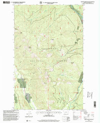
1997 Map of Newton Mountain
USGS Topo · Published 2000About this map
Kootenai National Forest dominates this landscape in northwestern Montana, where steep peaks and a network of Forest Service trails define the backcountry terrain. The mapping, revised in the late 1990s, documents a high-elevation environment centered on summits like Newton Mountain, Abe Lincoln Mountain, and Keystone Mountain. Local industrial history is visible at the Black Diamond Mine near Pine Creek, reflecting the mineral prospecting that shaped this corner of Lincoln County. The eastern edge of the quadrangle is defined by the Yaak River, which drops through the notable Yaak Falls. A complex system of foot travel is recorded here, including the Newton Trail, Tepee Mountain Trail, and the Meridian Guide Trail, providing a clear record of the access routes used by foresters and hikers before the turn of the millennium.
Find a feature on this map
27 named features on this map. Tap any name to fly to it.
Don’t see what you’re looking for? This feature index may not catch every label — zoom into the map to look around manually.
Map Details
Editions of this 1997 Newton Mountain Map
This is the sole edition of this map. No revisions or reprints were ever made.
Other maps of this area

1911 · Priest Lake
USGS Topo · 1:250,000

1913 · Priest Lake
USGS Topo · 1:250,000

1957 · Kalispell
USGS Topo · 1:250,000

1958 · Sandpoint
USGS Topo · 1:250,000

1960 · Kalispell
USGS Topo · 1:250,000

1961 · Kalispell
USGS Topo · 1:250,000

1963 · Sandpoint
USGS Topo · 1:250,000

1963 · Sylvanite
USGS Topo · 1:24,000

1963 · Mount Baldy
USGS Topo · 1:24,000

1963 · Pulpit Mountain
USGS Topo · 1:24,000