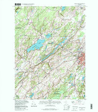
1994 Map of Newton West
USGS Topo · Published 1998About this map
Newton anchors the eastern edge of this late-twentieth-century landscape, where the concentrated development of the town gives way to the glaciated terrain of Sussex County. The Paulins Kill river valley carves a southwest path through the center of the sheet, flanked by numerous wildlife management areas and the significant waters of Swartswood Lake. Institutional landmarks are prominent in this era, including the Don Bosco College campus and St Pauls Abbey near Springdale.
Find a feature on this map
49 named features on this map. Tap any name to fly to it.
Don’t see what you’re looking for? This feature index may not catch every label — zoom into the map to look around manually.
Map Details
Editions of this 1994 Newton West Map
This is the sole edition of this map. No revisions or reprints were ever made.
Other maps of this area

1888 · Franklin
USGS Topo · 1:62,500

1888 · Hackettstown
USGS Topo · 1:62,500

1888 · Lake Hopatcong
USGS Topo · 1:62,500

1891 · Wallpack
USGS Topo · 1:62,500

1893 · Wallpack
USGS Topo · 1:62,500

1894 · Hackettstown
USGS Topo · 1:62,500

1894 · Lake Hopatcong
USGS Topo · 1:62,500

1894 · Franklin
USGS Topo · 1:62,500

1897 · Franklin
USGS Topo · 1:62,500

1898 · Lake Hopatcong
USGS Topo · 1:62,500