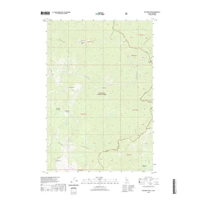
2020 Map of Nez Perce Peak
USGS Topo · Published 2020About this map
Nez Perce Peak and the high ridges of the Bitterroot National Forest define this landscape along the state line between Idaho and Montana. The map documents the high-altitude transit routes that have crossed this terrain for generations, notably the Nez Perce Indian Trail and the primitive track of the Magruder Corridor Rd. These routes follow the natural topography through landmarks like Nez Perce Pass and Vance Creek Saddle, connecting the drainage basins of Cayuse Cr and Halfway Cr.
Find a feature on this map
38 named features on this map. Tap any name to fly to it.
Don’t see what you’re looking for? This feature index may not catch every label — zoom into the map to look around manually.
Map Details
Editions of this 2020 Nez Perce Peak Map
This is the sole edition of this map. No revisions or reprints were ever made.
Other maps of this area

1956 · Elk City
USGS Topo · 1:250,000

1960 · Elk City
USGS Topo · 1:250,000

1960 · Painted Rocks Lake
USGS Topo · 1:62,500

1962 · Wood Hump
USGS Topo · 1:24,000

1962 · Beaver Jack Mtn
USGS Topo · 1:24,000

1962 · Blue Joint
USGS Topo · 1:24,000

1962 · Nez Perce Peak
USGS Topo · 1:24,000
1964 · Mount Jerusalem
USGS Topo · 1:24,000

1966 · Watchtower Peak
USGS Topo · 1:24,000
1966 · Burnt Strip Mtn
USGS Topo · 1:24,000