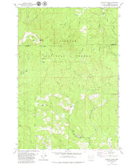
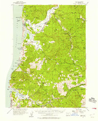
1979 Map of Niagara Creek
USGS Topo · Published 1979About this map
Siuslaw National Forest dominates this mountain landscape along the border of Tillamook and Yamhill counties. The area is defined by its timber and water resources, centered on the heights of Mount Hebo and Little Hebo. A specialized industrial and governmental presence is evident through the U S Military Reservation near the summit and various resource extraction sites like the Agency Creek Quarry. The complex hydrology of the Coast Range is well-documented, with drainages such as Agency Creek and Yoncalla Creek feeding into the Nestucca River. Remote infrastructure includes the curiously named Asinine Bridge and a Pumping Station along the Three Rivers. Local geography is further marked by the high-elevation North Lake and South Lake, providing a clear record of land use and forest management in the late 1970s.
Find a feature on this map
39 named features on this map. Tap any name to fly to it.
Don’t see what you’re looking for? This feature index may not catch every label — zoom into the map to look around manually.
Map Details
Editions of this 1979 Niagara Creek Map
This is the sole edition of this map. No revisions or reprints were ever made.
Other maps of this area

1941 · Nestucca Bay
USGS Topo · 1:62,500
1942 · Ginger Peak
USGS Topo · 1:62,500
1942 · Spirit Mtn
USGS Topo · 1:62,500

1942 · Nestucca Bay
USGS Topo · 1:62,500
1942 · Tillamook
USGS Topo · 1:62,500

1948 · Vancouver
USGS Topo · 1:250,000

1950 · Vancouver
USGS Topo · 1:250,000

1950 · Vancouver
USGS Topo · 1:250,000
1955 · Hebo
USGS Topo · 1:62,500
1955 · Blaine
USGS Topo · 1:62,500