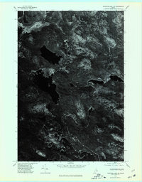
1975 Map of Nicatous Lake NW
USGS Topo · Published 1980About this map
Nicatous Lake dominates the central portion of this orthophotoquad, captured through aerial photography in the mid-1970s. The landscape is a complex pattern of northern Maine timberland and water, defined by the winding course of the Passadumkeag River in the north. Unlike traditional topographic maps, this imagery-based survey provides a raw view of the ground cover, highlighting the expansive wetland area labeled as Heath. The high-contrast imagery distinguishes between the dark, still waters of the lake's coves and the dense, textured canopy of the surrounding Hancock County forest. This specific visual record preserves the exact state of the shoreline and drainage patterns before later 20th-century shifts in land management or natural succession altered the footprint of the local wetlands.
Find a feature on this map
3 named features on this map. Tap any name to fly to it.
Don’t see what you’re looking for? This feature index may not catch every label — zoom into the map to look around manually.
Map Details
Editions of this 1975 Nicatous Lake NW Map
This is the sole edition of this map. No revisions or reprints were ever made.
Other maps of this area

1920 · Winn
USGS Topo · 1:62,500

1931 · Springfield
USGS Topo · 1:48,000

1931 · Saponac
USGS Topo · 1:48,000

1932 · Nicatous Lake
USGS Topo · 1:48,000

1934 · Saponac
USGS Topo · 1:62,500

1934 · Nicatous Lake
USGS Topo · 1:62,500

1934 · Springfield
USGS Topo · 1:62,500

1954 · Millinocket
USGS Topo · 1:250,000

1957 · Saponac
USGS Topo · 1:62,500

1958 · Millinocket
USGS Topo · 1:250,000