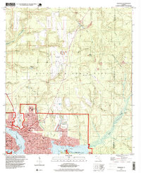
1994 Map of Niceville
USGS Topo · Published 1999About this map
Niceville and Valparaiso sit at the confluence of several coastal waterways, where the waters of Boggy Bayou and Rocky Bayou meet. This mid-1990s record shows a landscape defined by significant military and educational presence, with Eglin Air Force Base spanning much of the northern terrain, including the Aux Field No 2 (Abandoned). The residential fabric of the area is well-documented through localized points such as the Pinecrest Community and Bolton, alongside essential local institutions like Okaloosa Walton Jr College and Plew Sch. For genealogists, the map identifies specific burial sites including Sunset Cem and Early Cem. Environmental features are prominent, ranging from the protected lands of Fred Gannon Rocky Bayou State Park to the intricate network of inland streams such as Swift Creek and Turkey Creek.
Find a feature on this map
57 named features on this map. Tap any name to fly to it.
Don’t see what you’re looking for? This feature index may not catch every label — zoom into the map to look around manually.
Map Details
Editions of this 1994 Niceville Map
This is the sole edition of this map. No revisions or reprints were ever made.
Other maps of this area

1934 · Holt
USGS Topo · 1:48,000

1934 · Niceville
USGS Topo · 1:48,000

1935 · Villa Tasso
USGS Topo · 1:48,000

1936 · Niceville
USGS Topo · 1:62,500

1937 · Holt
USGS Topo · 1:62,500

1938 · Mary Esther
USGS Topo · 1:62,500

1938 · Villa Tasso
USGS Topo · 1:62,500

1956 · Niceville
USGS Topo · 1:62,500

1956 · Fort Walton Beach
USGS Topo · 1:62,500

1956 · Holt
USGS Topo · 1:62,500