
1934 Map of Niceville
USGS Topo · Published 1934About this map
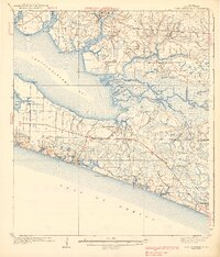
Choctawhatchee National Forest dominates the landscape of this 1930s survey, illustrating a region defined by its timber resources and maritime geography. Along the southern coast, the developing settlements of Niceville and Valparaiso sit at the confluence of several waterways, including Boggy Bayou, Toms Bayou, and Rocky Bayou. The interior is crisscrossed by an extensive network of forestry roads and lookout stations like the Jackson Lookout Tower, reflecting the era's intensive forest management and fire prevention efforts.
Find a feature on this map
82 named features on this map. Tap any name to fly to it.
Don’t see what you’re looking for? This feature index may not catch every label — zoom into the map to look around manually.
Map Details
Editions of this 1934 Niceville Map
This is the sole edition of this map. No revisions or reprints were ever made.
Other maps of this area

1934 · Holt
USGS Topo · 1:48,000

1935 · Villa Tasso
USGS Topo · 1:48,000

1935 · De Funiak Springs
USGS Topo · 1:48,000

1936 · Niceville
USGS Topo · 1:62,500

1936 · Point Washington
USGS Topo · 1:48,000

1937 · Holt
USGS Topo · 1:62,500

1938 · Mary Esther
USGS Topo · 1:62,500

1938 · Villa Tasso
USGS Topo · 1:62,500

1938 · De Funiak Springs
USGS Topo · 1:62,500
1939 · Point Washington
USGS Topo · 1:62,500