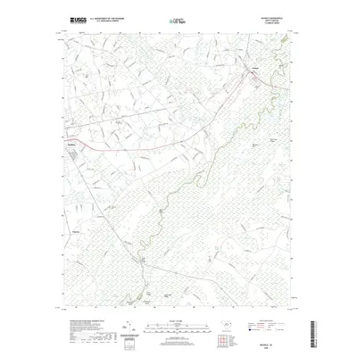
2020 Map of Nichols
USGS Topo · Published 2020About this map
The confluence of the Lumber River and the Little Pee Dee River dominates this portion of the Coastal Plain, creating a complex landscape of winding channels, swamps, and bays. The town of Nichols sits at the northern edge of this drainage system, while Mullins occupies the western plateau. The terrain is characterized by distinctive formations like the Big Sand Hills and Bear Sand Ridges, which rise above the surrounding wetlands of Back Swamp and Raft Swamp. Numerous family and community landmarks are scattered throughout the rural sections, including the Old State Cemetery and the Nazarene Cemetery near Gapway. The mapping of these waterways reveals a network of islands and named reaches such as Lewis Island, Turkeypen Island, and the curved shoreline of Red Bluff, illustrating the historical reliance on these river corridors for navigation and boundary marking between Marion and Horry counties.
Find a feature on this map
159 named features on this map. Tap any name to fly to it.
Don’t see what you’re looking for? This feature index may not catch every label — zoom into the map to look around manually.
Map Details
Editions of this 2020 Nichols Map
This is the sole edition of this map. No revisions or reprints were ever made.
Other maps of this area

1943 · Pages Mill
USGS Topo · 1:62,500

1946 · Mullins
USGS Topo · 1:24,000

1947 · Centenary
USGS Topo · 1:24,000

1947 · Mullins
USGS Topo · 1:24,000

1948 · Galivants Ferry
USGS Topo · 1:24,000

1948 · Nichols
USGS Topo · 1:24,000

1948 · Bayboro
USGS Topo · 1:24,000

1949 · Bayboro
USGS Topo · 1:24,000

1949 · Duford
USGS Topo · 1:24,000

1950 · Galivants Ferry
USGS Topo · 1:24,000