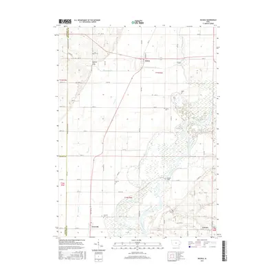
2015 Map of Nichols
USGS Topo · Published 2015About this map
Nichols and Conesville anchor this survey of the low-lying terrain along the Cedar River, where the landscape is defined by an intricate network of waterways and wetlands. The river dominates the eastern and southern sections of the map, flanked by Hockeys Slough, Crane Creek, and Cone Lake. This environment shaped the region’s development, necessitating infrastructure like the Big Slough Creek Bridge and McKeown Bridge to connect the small agricultural settlements. For those tracing local families, the map is particularly dense with burial sites including Lone Tree Cemetery, Rogers Cemetery, and Watkins Cemetery. The presence of Cranston in the southeast corner further illustrates the scattered nature of these small rural communities. The map captures a moment in the mid-2010s where the drainage patterns of Wapsinonoc Creek and Pike Creek continue to dictate the placement of roads such as Oak Grove Road and County Highway G28.
Find a feature on this map
51 named features on this map. Tap any name to fly to it.
Don’t see what you’re looking for? This feature index may not catch every label — zoom into the map to look around manually.
Map Details
Editions of this 2015 Nichols Map
This is the sole edition of this map. No revisions or reprints were ever made.
Other maps of this area

1891 · Wilton Junction
USGS Topo · 1:62,500

1894 · West Liberty
USGS Topo · 1:62,500

1901 · Stanwood
USGS Topo · 1:125,000

1948 · Muscatine
USGS Topo · 1:62,500

1958 · Davenport
USGS Topo · 1:250,000

1961 · Davenport
USGS Topo · 1:250,000

1962 · Davenport
USGS Topo · 1:250,000
1965 · West Liberty
USGS Topo · 1:24,000

1965 · Letts
USGS Topo · 1:24,000
1965 · Muscatine NW
USGS Topo · 1:24,000