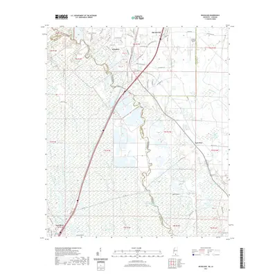
2021 Map of Nicholson
USGS Topo · Published 2021About this map
Picayune and the neighboring community of Nicholson sit at the edge of a dense fluvial landscape where the Mississippi-Louisiana border follows the winding course of the Pearl River. The terrain is defined by the expansive Honey Island Swamp, a complex network of waterways including Crooked Bayou, Black Bayou, and the McCall River. This environment created a natural barrier between Pearl River County and St. Tammany Parish, influencing the development of local roads like Old US Hwy 11 and the modern Shuttle Pkwy corridor leading toward the coast. Farther east, the landscape transitions into slightly higher ground, though it remains crisscrossed by drainages such as Turtleskin Cr and Indian Bayou. Genealogists will note the location of Turtleskin Cem and Pearl River Cem, while the northern portion of the map highlights the development around the Picayune Municipal Airport. The map also captures numerous named water features like Spencer Mill Lake and Murdock Eddy Lake, reflecting the region's deep ties to the river system.
Find a feature on this map
89 named features on this map. Tap any name to fly to it.
Don’t see what you’re looking for? This feature index may not catch every label — zoom into the map to look around manually.
Map Details
Editions of this 2021 Nicholson Map
This is the sole edition of this map. No revisions or reprints were ever made.
Other maps of this area

1914 · Nicholson
USGS Topo · 1:62,500

1921 · Nicholson
USGS Topo · 1:62,500

1935 · Slidell
USGS Topo · 1:62,500

1939 · Slidell
USGS Topo · 1:62,500

1941 · Honey Island
USGS Topo · 1:31,680

1942 · Walkiah Bluff
USGS Topo · 1:31,680

1950 · Haaswood
USGS Topo · 1:31,680

1950 · Slidell
USGS Topo · 1:62,500

1953 · Mobile
USGS Topo · 1:250,000

1954 · Haaswood
USGS Topo · 1:31,680