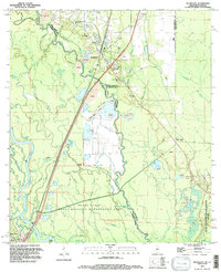
1993 Map of Nicholson
USGS Topo · Published 1995About this map
The Pearl River forms a complex labyrinth of winding waterways and low-lying wetlands along the border of Mississippi and Louisiana, as documented in this 1993 field check. The landscape is defined by the dense network of bayous including McCall Bayou, Rones Bayou, and Indian Bayou, which weave through the Pearl River State Wildlife Management Area. To the east, the edge of the John C Stennis Space Center (NASA) encroaches on the traditional settlement patterns of Nicholson and Santa Rosa.
Find a feature on this map
66 named features on this map. Tap any name to fly to it.
Don’t see what you’re looking for? This feature index may not catch every label — zoom into the map to look around manually.
Map Details
Editions of this 1993 Nicholson Map
This is the sole edition of this map. No revisions or reprints were ever made.
Other maps of this area

1914 · Nicholson
USGS Topo · 1:62,500

1921 · Nicholson
USGS Topo · 1:62,500

1935 · Slidell
USGS Topo · 1:62,500

1939 · Slidell
USGS Topo · 1:62,500

1941 · Honey Island
USGS Topo · 1:31,680

1942 · Walkiah Bluff
USGS Topo · 1:31,680

1950 · Haaswood
USGS Topo · 1:31,680

1950 · Slidell
USGS Topo · 1:62,500

1953 · Mobile
USGS Topo · 1:250,000

1954 · Haaswood
USGS Topo · 1:31,680