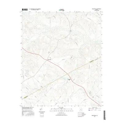
2017 Map of Nicklesville
USGS Topo · Published 2017About this map
Nicklesville sits as a central crossroads in this pocket of central Georgia, where rural routes connect the small settlements of Wilkinson County and Laurens County. The landscape is defined by the winding course of Big Sandy Creek and its many tributaries, including Cedar Creek and South Sandy Creek. This hydrology supported local industries, as seen at Chappells Mill and nearby Chappells Pond. Family and community history is anchored by several rural burying grounds like Big Sandy Cemetery and the Hagin-Fordham Cemetery. The drainage patterns of Long Branch and Maiden Creek illustrate a deeply dissected terrain that influenced the placement of early homesteads and bridges, such as Hall Bridge. For the genealogist, the distribution of these small cemeteries and named homestead roads provides clues to family lineages in this long-settled agricultural region.
Find a feature on this map
56 named features on this map. Tap any name to fly to it.
Don’t see what you’re looking for? This feature index may not catch every label — zoom into the map to look around manually.
Map Details
Editions of this 2017 Nicklesville Map
This is the sole edition of this map. No revisions or reprints were ever made.
Other maps of this area

1916 · Irwinton
USGS Topo · 1:62,500

1920 · Irwinton
USGS Topo · 1:62,500

1957 · Macon
USGS Topo · 1:250,000

1958 · Macon
USGS Topo · 1:250,000

1962 · Oconee
USGS Topo · 1:24,000

1964 · Macon
USGS Topo · 1:250,000
1973 · Irwinton
USGS Topo · 1:24,000
1973 · Toomsboro
USGS Topo · 1:24,000

1974 · Cow Hell Swamp
USGS Topo · 1:24,000

1974 · Danville East
USGS Topo · 1:24,000