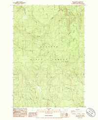
1985 Map of Nicolai Mtn
USGS Topo · Published 1985About this map
The timber-rich landscape of Clatsop State Forest dominates this mid-1980s topographical survey, centered on the prominent elevation of Nicolai Mtn. The terrain is defined by a dense network of drainage systems, including Gnat Creek and Fishhawk Creek, which carve through the high ridges. Human activity is largely industrial and utility-focused, indicated by the presence of a Quarry, a Gravel Pit, and a Radio Facility near the summit of Nicolai Ridge.
Find a feature on this map
29 named features on this map. Tap any name to fly to it.
Don’t see what you’re looking for? This feature index may not catch every label — zoom into the map to look around manually.
Map Details
Editions of this 1985 Nicolai Mtn Map
This is the sole edition of this map. No revisions or reprints were ever made.
Other maps of this area

1939 · Saddle Mountain
USGS Topo · 1:62,500

1940 · Svensen
USGS Topo · 1:62,500

1941 · Keasey
USGS Topo · 1:62,500

1941 · Cathlamet
USGS Topo · 1:62,500

1943 · Keasey
USGS Topo · 1:62,500

1943 · Saddle Mtn.
USGS Topo · 1:62,500

1948 · Vancouver
USGS Topo · 1:250,000

1950 · Vancouver
USGS Topo · 1:250,000

1950 · Vancouver
USGS Topo · 1:250,000

1953 · Hoquiam
USGS Topo · 1:250,000