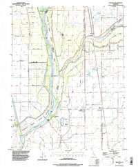
1992 Map of Nicolaus
USGS Topo · Published 1997About this map
The confluence of the Feather River and the Bear River defines this landscape in southern Sutter County, where massive levee systems and the Sutter By-Pass protect the fertile river bottomlands. The settlement of Nicolaus sits along the bend of the Feather, serving as a historic hub for the surrounding agricultural tracts. Further east, the rail-oriented villages of Rio Oso, East Nicolaus, and Trowbridge follow the line of the Southern Pacific railroad. The map reveals an intricate network of drainage sloughs, including Ping Slough and Yankee Slough, which cut across the terrain of New Helvetia. For genealogists, the map identifies local burial grounds like Nicolaus Cemetery and Fairview Cemetery, while nature enthusiasts can trace the riparian borders of the Feather River State Wildlife Area, including the secluded Lake of the Woods.
Find a feature on this map
51 named features on this map. Tap any name to fly to it.
Don’t see what you’re looking for? This feature index may not catch every label — zoom into the map to look around manually.
Map Details
Editions of this 1992 Nicolaus Map
This is the sole edition of this map. No revisions or reprints were ever made.
Other maps of this area

1888 · Marysville
USGS Topo · 1:125,000

1888 · Smartsville
USGS Topo · 1:125,000

1891 · Sacramento
USGS Topo · 1:125,000

1891 · Marysville
USGS Topo · 1:125,000

1891 · Smartsville
USGS Topo · 1:125,000

1892 · Sacramento
USGS Topo · 1:125,000

1892 · Smartsville
USGS Topo · 1:125,000

1893 · Sacramento
USGS Topo · 1:125,000

1894 · Smartsville
USGS Topo · 1:125,000

1894 · Marysville
USGS Topo · 1:125,000