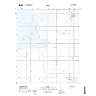
2018 Map of Niland
USGS Topo · Published 2018About this map
The Imperial Valley landscape is defined by an intricate network of irrigation infrastructure and the receding shoreline of the Salton Sea. This survey shows the agricultural engine of the region, where a dense alphabetical grid of water channels like T Drain, S Drain, and R Lateral sustain the desert fields. In the northern portion of the map, the settlement of Niland serves as a hub, with its grid of streets including Main St and Beal Rd transitioning into the rural reaches of the valley. To the south, Calipatria anchors the map, featuring the Cliff Hatfield Memorial Airport. Notable topographic features emerge from the shoreline and wetlands, including Mullet Island, Red Island, and Rock Hill, the latter of which is accessible via the Rock Hill Trail. The map also identifies the small locale of Estelle, situated near the junction of several drainage and lateral systems.
Find a feature on this map
94 named features on this map. Tap any name to fly to it.
Don’t see what you’re looking for? This feature index may not catch every label — zoom into the map to look around manually.
Map Details
Editions of this 2018 Niland Map
This is the sole edition of this map. No revisions or reprints were ever made.
Other maps of this area

1940 · Iris
USGS Topo · 1:62,500

1940 · Frink
USGS Topo · 1:62,500

1940 · Iris Pass
USGS Topo · 1:62,500

1944 · Calipatria
USGS Topo · 1:62,500

1944 · Frink
USGS Topo · 1:62,500

1945 · Iris Pass
USGS Topo · 1:62,500

1945 · Iris
USGS Topo · 1:62,500

1954 · Salton Sea
USGS Topo · 1:250,000

1955 · Salton Sea
USGS Topo · 1:250,000
1956 · Iris
USGS Topo · 1:24,000