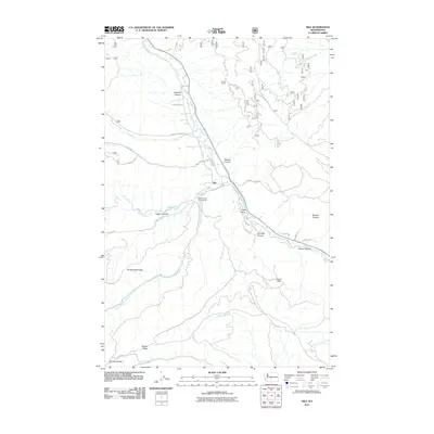
2011 Map of Nile
USGS Topo · Published 2011About this map
The Naches River corridor defines this part of Yakima County, where the small settlement of Nile sits at the junction of valley roads and mountain canyons. This 2011 survey documents a landscape where agricultural grazing and forest recreation converge, featuring named points like Sanford Pasture and the Hanging Tree Campground. The complex topography is marked by several deep drainages including Johnson Canyon, Garrett Canyon, and Carmack Canyon, which cut through the high ground of Cowpuncher Ridge and Bethel Ridge.
Find a feature on this map
40 named features on this map. Tap any name to fly to it.
Don’t see what you’re looking for? This feature index may not catch every label — zoom into the map to look around manually.
Map Details
Editions of this 2011 Nile Map
This is the sole edition of this map. No revisions or reprints were ever made.
Other maps of this area

1899 · Ellensburg
USGS Topo · 1:125,000

1901 · Ellensburg
USGS Topo · 1:125,000

1902 · Mount Aix
USGS Topo · 1:125,000

1904 · Mt Aix
USGS Topo · 1:125,000

1950 · Yakima
USGS Topo · 1:250,000

1958 · Yakima
USGS Topo · 1:250,000

1961 · Yakima
USGS Topo · 1:250,000

1967 · Tieton Basin
USGS Topo · 1:24,000

1971 · Nile
USGS Topo · 1:24,000
1971 · Milk Canyon
USGS Topo · 1:24,000