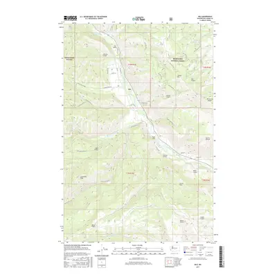
2017 Map of Nile
USGS Topo · Published 2017About this map
Nile Valley and the small settlement of Nile occupy a strategic bend in the Naches River, where the valley floor provides a narrow corridor of level ground between steep ridges. The landscape is defined by the massive bulk of Cleman Mtn to the northeast and the high reaches of Bethel Ridge to the southwest. This area, largely contained within the Snoqualmie National Forest, shows a complex network of forest roads and land management tracks that penetrate deep canyons and high pastures. Significant watercourses like Rattlesnake Creek and Nile Cr feed the main river, cutting through terrain marked by named landmarks such as Eagle Rock and Cowpuncher Ridge. The transition from the irrigated river bottom to the high grazing lands of Sanford Pasture and Carrol Flats illustrates the traditional land-use patterns of Yakima County's high country.
Find a feature on this map
53 named features on this map. Tap any name to fly to it.
Don’t see what you’re looking for? This feature index may not catch every label — zoom into the map to look around manually.
Map Details
Editions of this 2017 Nile Map
This is the sole edition of this map. No revisions or reprints were ever made.
Other maps of this area

1899 · Ellensburg
USGS Topo · 1:125,000

1901 · Ellensburg
USGS Topo · 1:125,000

1902 · Mount Aix
USGS Topo · 1:125,000

1904 · Mt Aix
USGS Topo · 1:125,000

1950 · Yakima
USGS Topo · 1:250,000

1958 · Yakima
USGS Topo · 1:250,000

1961 · Yakima
USGS Topo · 1:250,000

1967 · Tieton Basin
USGS Topo · 1:24,000

1971 · Nile
USGS Topo · 1:24,000
1971 · Milk Canyon
USGS Topo · 1:24,000