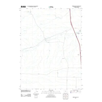
2012 Map of Nimmo Ranch
USGS Topo · Published 2012About this map
Nimmo Ranch and other established homesteads like Moyer Ranch and Homes Ranch anchor this corner of Laramie County, illustrating the enduring cattle-ranching heritage of the high plains. The landscape is defined by the vital movement of water, where natural drainage through Horse Cr and Little Bear Cr is augmented by complex irrigation works like Horse Creek Ditch Number 1 and the Snow Cattle Co Ditch Number 2. These human-made channels reveal the intensive efforts required to manage water in an arid environment, supporting the livestock operations that give the area its character. Along the eastern edge, the modern transit corridor follows the I-25 Service Rd E, while a network of rural routes including True Rd and various county roads connect the scattered ranch houses across the draws and creeks.
Find a feature on this map
22 named features on this map. Tap any name to fly to it.
Don’t see what you’re looking for? This feature index may not catch every label — zoom into the map to look around manually.
Map Details
Editions of this 2012 Nimmo Ranch Map
This is the sole edition of this map. No revisions or reprints were ever made.
Other maps of this area

1905 · Sherman
USGS Topo · 1:125,000

1911 · Cheyenne
USGS Topo · 1:125,000

1914 · Cheyenne
USGS Topo · 1:125,000

1954 · Cheyenne
USGS Topo · 1:250,000

1958 · Cheyenne
USGS Topo · 1:250,000

1962 · P O Ranch
USGS Topo · 1:24,000

1962 · Federal
USGS Topo · 1:24,000

1962 · Dereemer Ranch
USGS Topo · 1:24,000

1962 · Moffett Ranch
USGS Topo · 1:24,000
1962 · Farthing Ranch
USGS Topo · 1:24,000