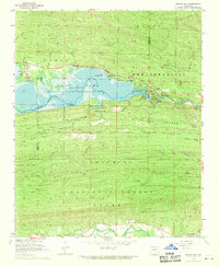
1968 Map of Nimrod Dam
USGS Topo · Published 1970About this map
Nimrod Lake dominates the landscape at the boundary of Yell and Perry Counties, its waters controlled by the dam and monitored by a Gaging Station. This survey captures the transition of the Fourche River valley into a managed recreational and conservation zone during the late 1960s. High ground is defined by Mason Ridge and Ola Mountain to the north, while the Ouachita Mountains rise to the south, featuring a Lookout Tower atop Cove Mountain. Settlement is concentrated at Fourche Junction, where road networks converge near the dam's outflow. To the south along the South Fourche La Fave River, evidence of rural community life persists at Valley Home Ch and the Ark Sch. The map also delineates extensive public lands including the Nimrod State Game Management Area and various shoreline parks such as Quarry Cove Recreation Area.
Find a feature on this map
47 named features on this map. Tap any name to fly to it.
Don’t see what you’re looking for? This feature index may not catch every label — zoom into the map to look around manually.
Map Details
Editions of this 1968 Nimrod Dam Map
This is the sole edition of this map. No revisions or reprints were ever made.
Other maps of this area

1888 · Dardanelle #4
USGS Topo · 1:62,500

1888 · Dardanelle #3
USGS Topo · 1:62,500

1890 · Hot Springs
USGS Topo · 1:125,000

1890 · Dardanelle
USGS Topo · 1:125,000

1894 · Hot Springs
USGS Topo · 1:125,000

1955 · Little Rock
USGS Topo · 1:250,000

1956 · Little Rock
USGS Topo · 1:250,000

1956 · Russellville
USGS Topo · 1:250,000

1960 · Little Rock
USGS Topo · 1:250,000

1964 · Russellville
USGS Topo · 1:250,000