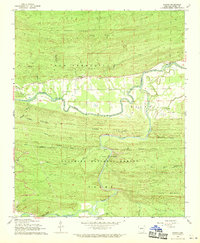
1968 Map of Nimrod
USGS Topo · Published 1970About this map
The Fourche La Fave River snakes through the central landscape of Perry County, defining the settlement patterns of Nimrod and Aplin in the late 1960s. This survey, mapped by the U. S. Forest Service, captures a rural Arkansas corridor where family history is anchored by sites like Nimrod Cem and Deberrie Cem. To the south, the terrain becomes more dramatic as the Ouachita National Forest encompasses landmarks such as Goat Bluff and the rising elevations of Link Mountain and Cedar Mountain. The presence of a Lookout Tower and a Gaging Station reflects the active management of the forest and the river system. Small communities and isolated crossings, including Hollis and Deberrie, are connected by winding roads through Long Hollow, illustrating the enduring relationship between the river valleys and the upland timber of the Ouachita region.
Find a feature on this map
35 named features on this map. Tap any name to fly to it.
Don’t see what you’re looking for? This feature index may not catch every label — zoom into the map to look around manually.
Map Details
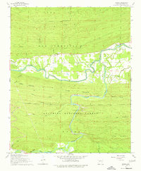
Editions of this 1968 Nimrod Map
2 editions found
Other maps of this area

1888 · Dardanelle #4
USGS Topo · 1:62,500

1889 · Morrilton No. 3
USGS Topo · 1:62,500

1890 · Benton
USGS Topo · 1:125,000

1890 · Hot Springs
USGS Topo · 1:125,000

1890 · Dardanelle
USGS Topo · 1:125,000

1892 · Morrillton
USGS Topo · 1:125,000

1894 · Morrillton
USGS Topo · 1:125,000

1894 · Hot Springs
USGS Topo · 1:125,000

1894 · Benton
USGS Topo · 1:125,000

1955 · Little Rock
USGS Topo · 1:250,000