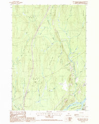
1988 Map of Nine Meadow Ridge
USGS Topo · Published 1988About this map
The Penobscot River flows along the southeastern corner of this landscape, defining the character of the riverfront communities of Lincoln Center and Chester. Large river features like Mattanawcook Island and Chokecherry Island highlight the complex waterway that supported local industry and transport. Further north, the terrain is dominated by a series of glacial ridges and wetlands, most notably the prominent The Horseback and Nine Meadow Ridge.
Find a feature on this map
40 named features on this map. Tap any name to fly to it.
Don’t see what you’re looking for? This feature index may not catch every label — zoom into the map to look around manually.
Map Details
Editions of this 1988 Nine Meadow Ridge Map
This is the sole edition of this map. No revisions or reprints were ever made.
Other maps of this area

1920 · Winn
USGS Topo · 1:62,500

1940 · Mattawamkeag
USGS Topo · 1:62,500

1942 · Lincoln
USGS Topo · 1:62,500

1942 · Mattawamkeag
USGS Topo · 1:62,500

1951 · Millinocket
USGS Topo · 1:62,500

1954 · Millinocket
USGS Topo · 1:250,000

1957 · Lincoln
USGS Topo · 1:62,500

1958 · Millinocket
USGS Topo · 1:250,000

1960 · Millinocket
USGS Topo · 1:250,000
1960 · Winn
USGS Topo · 1:62,500