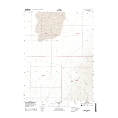
2014 Map of Ninemile Canyon
USGS Topo · Published 2014About this map
Independence Valley occupies the northern expanse of this Elko County quadrangle, transitioning into the steep, rising terrain of the Pequop Mountains to the southeast. The landscape is defined by its drainage patterns, most notably the seasonal flow of Cole Creek and the eponymous Ninemile Canyon. This high-desert environment shows a classic Great Basin topographic profile, where broad alluvial basins meet sharp mountain ridges. The map meticulously documents the transition from the valley floor to the higher elevations of the Pequops, providing a clear record of the area's natural drainage and the geographic features that define this portion of northeastern Nevada.
Find a feature on this map
9 named features on this map. Tap any name to fly to it.
Don’t see what you’re looking for? This feature index may not catch every label — zoom into the map to look around manually.
Map Details
Editions of this 2014 Ninemile Canyon Map
This is the sole edition of this map. No revisions or reprints were ever made.
Other maps of this area

1953 · Spruce Mountain
USGS Topo · 1:62,500

1953 · Spruce Mountain 4
USGS Topo · 1:62,500

1955 · Elko
USGS Topo · 1:250,000

1958 · Elko
USGS Topo · 1:250,000

1962 · Elko
USGS Topo · 1:250,000

1965 · Elko
USGS Topo · 1:250,000

1968 · Independence Valley SW
USGS Topo · 1:24,000

1968 · Ventosa
USGS Topo · 1:24,000

1968 · Independence Valley SE
USGS Topo · 1:24,000
1985 · Wendover
USGS Topo · 1:100,000