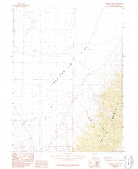
1986 Map of Ninemile Canyon
USGS Topo · Published 1986About this map
The high desert landscape of Independence Valley dominates this 1980s Elko County survey, where the valley floor meets the rising slopes of the Pequop Mountains. This transition from the flat basin to the montane terrain is marked by the drainage of Ninemile Canyon and Cole Creek, which flow toward the seasonally arid Alkali Flat in the north. Land use in this corner of Nevada is indicated by sparse but essential features for the ranching and industrial economy, including a Corral near the mountain base and a Gravel Pit near the creek. The map captures a moment in the mid-1980s when traditional land markers, such as the township boundaries of T 33 N and T 32 N, remained the primary points of orientation in this sparsely populated region.
Find a feature on this map
8 named features on this map. Tap any name to fly to it.
Don’t see what you’re looking for? This feature index may not catch every label — zoom into the map to look around manually.
Map Details
Editions of this 1986 Ninemile Canyon Map
This is the sole edition of this map. No revisions or reprints were ever made.
Other maps of this area

1953 · Spruce Mountain
USGS Topo · 1:62,500

1953 · Spruce Mountain 4
USGS Topo · 1:62,500

1955 · Elko
USGS Topo · 1:250,000

1958 · Elko
USGS Topo · 1:250,000

1962 · Elko
USGS Topo · 1:250,000

1965 · Elko
USGS Topo · 1:250,000

1968 · Independence Valley SW
USGS Topo · 1:24,000

1968 · Ventosa
USGS Topo · 1:24,000

1968 · Independence Valley SE
USGS Topo · 1:24,000
1985 · Wendover
USGS Topo · 1:100,000