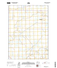
2020 Map of Ninemile Slough
USGS Topo · Published 2020About this map
Harney Valley defines the wide, marshy expanse of this rural Oregon landscape, where the meandering course of Ninemile Slough cuts through the basin. The map reveals a land structured by long-distance section lines and a grid of rural roads, many bearing local family or descriptive names like Ruhl Rd, Hutchenson Rd, and Cotton Tail Ln. A notable landmark for regional travel is Hooks Strip, an airstrip positioned amongst the wetlands and ranching tracts. The terrain is characterized by its low-lying hydrology, with intermittent water features and drainage patterns typical of the high desert basin. This 2020 edition offers a detailed look at the modern surveying of the area, maintaining the historic township and range divisions that have governed this part of the county since the early frontier era.
Find a feature on this map
27 named features on this map. Tap any name to fly to it.
Don’t see what you’re looking for? This feature index may not catch every label — zoom into the map to look around manually.
Map Details
Editions of this 2020 Ninemile Slough Map
This is the sole edition of this map. No revisions or reprints were ever made.
Other maps of this area

1955 · Burns
USGS Topo · 1:250,000

1958 · Burns
USGS Topo · 1:250,000

1959 · Burns
USGS Topo · 1:250,000

1959 · Harney
USGS Topo · 1:62,500

1959 · Lawen
USGS Topo · 1:62,500

1960 · Crane
USGS Topo · 1:62,500

1973 · Buchanan
USGS Topo · 1:24,000

1973 · Carson Point
USGS Topo · 1:24,000

1978 · Malheur Lake
USGS Topo · 1:100,000

1978 · Stinkingwater Mountains
USGS Topo · 1:100,000