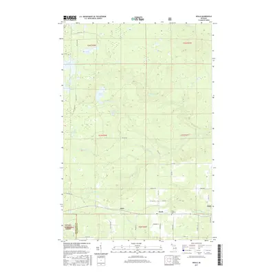
2017 Map of Nisula
USGS Topo · Published 2017About this map
Nisula and Alston serve as the primary focal points of this Copper Country landscape, situated within the southwestern reaches of Houghton County. The area is defined by a dense network of water bodies and tributaries, including the W Br Otter River and the secluded Lake Fifteen. Much of the southern and western terrain falls within the Ottawa National Forest, where the topography is marked by localized elevation shifts near Otter Falls. Local family history is centered around the Nisula Lutheran Cem and the small settlements that grew along the early transit corridors. The map details numerous rural routes such as Alston Trl and Heikkila Rd, which connect isolated homesteads and forested tracts. This 2017 survey reflects a region still deeply tied to its natural environment, where timber and water remain the dominant geographic features.
Find a feature on this map
49 named features on this map. Tap any name to fly to it.
Don’t see what you’re looking for? This feature index may not catch every label — zoom into the map to look around manually.
Map Details
Editions of this 2017 Nisula Map
This is the sole edition of this map. No revisions or reprints were ever made.
Other maps of this area

1954 · Rousseau
USGS Topo · 1:62,500

1954 · Pelkie
USGS Topo · 1:62,500

1954 · Winona
USGS Topo · 1:62,500

1954 · Sidnaw
USGS Topo · 1:62,500

1958 · Iron River
USGS Topo · 1:250,000

1960 · Iron River
USGS Topo · 1:250,000

1961 · Iron River
USGS Topo · 1:250,000

1967 · Iron River
USGS Topo · 1:250,000
1982 · Nisula
USGS Topo · 1:25,000
1982 · Donken
USGS Topo · 1:25,000