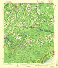
1942 Map of Nixonville
USGS Topo · Published 1942About this map
The Waccamaw River winds through a landscape of dense swamps and rising bluffs just inland from the South Carolina coast. This area of Horry County is defined by its watery geography, where the newly constructed Intracoastal Waterway cuts a straight path toward the Atlantic Ocean. Settlements like Nixonville, Red Bluff, and Grahamville serve as focal points for a rural community reliant on timber and river access. The map reveals an extensive network of segregated education and local worship, documented through labels for the Poplar Training Sch, Eldorado Sch No 1, and numerous country churches such as Mt Calvary Ch and McNeal Chapel. Notable family landmarks, including the Graham Cem and Chestnut Cem, offer significant detail for those researching the deep-rooted genealogies of this coastal plain region.
Find a feature on this map
115 named features on this map. Tap any name to fly to it.
Don’t see what you’re looking for? This feature index may not catch every label — zoom into the map to look around manually.
Map Details
Editions of this 1942 Nixonville Map
2 editions found
Other maps of this area

1937 · Myrtle Beach
USGS Topo · 1:48,000

1937 · Nixonville
USGS Topo · 1:48,000

1940 · Myrtle Beach
USGS Topo · 1:62,500

1942 · Nixonville
USGS Topo · 1:62,500

1943 · Pireway
USGS Topo · 1:31,680

1943 · Wampee
USGS Topo · 1:24,000

1943 · Bucksville
USGS Topo · 1:24,000

1943 · Adrian
USGS Topo · 1:24,000

1943 · Conway
USGS Topo · 1:24,000

1944 · Longs
USGS Topo · 1:31,680