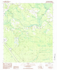
1984 Map of Nixonville
USGS Topo · Published 1984About this map
The Waccamaw River winds through a landscape of swampy lowlands and bay depressions in this mid-1980s look at Horry County. Settlement centers on the small communities of Grahamville and Nixonville, with family history preserved at Price Cem and Thompkins Cem. This environment is defined by its water-access points like Lees Landing and Bear Bluff Landing, and the many “bays”—distinctive Carolina bay geological features—including McCoy Bay, Cottonpatch Bay, and Tuckahoe Bay.
Find a feature on this map
50 named features on this map. Tap any name to fly to it.
Don’t see what you’re looking for? This feature index may not catch every label — zoom into the map to look around manually.
Map Details
Editions of this 1984 Nixonville Map
This is the sole edition of this map. No revisions or reprints were ever made.
Other maps of this area

1937 · Myrtle Beach
USGS Topo · 1:48,000

1937 · Nixonville
USGS Topo · 1:48,000

1940 · Myrtle Beach
USGS Topo · 1:62,500

1942 · Nixonville
USGS Topo · 1:62,500

1943 · Bucksville
USGS Topo · 1:24,000

1943 · Adrian
USGS Topo · 1:24,000

1943 · Conway
USGS Topo · 1:24,000

1944 · Adrian
USGS Topo · 1:31,680

1949 · Georgetown
USGS Topo · 1:250,000

1967 · Georgetown
USGS Topo · 1:250,000